As of December 1, 2022, the Markup App is no longer accepting incoming markups. You can still log in to review your markup history, browse the map, or identify features, but cannot submit markups. Markups submitted through November 30, 2022 will be considered for review and implementation in the final static version of the NHD and WBD. Any markups submitted after the deadline will not be considered for implementation..
Similar to "marking up" a printed map, a "markup" is a digital suggestion for improving the USGS National Hydrography Dataset (NHD) or Watershed Boundary Dataset (WBD). Markups can suggest edits to feature geometry (using a point, polyline, or polygon shape) and/or attributes.
Note: Markups are suggestions for improvement to NHD and WBD datasets; no actual edits occur in the Markup App.
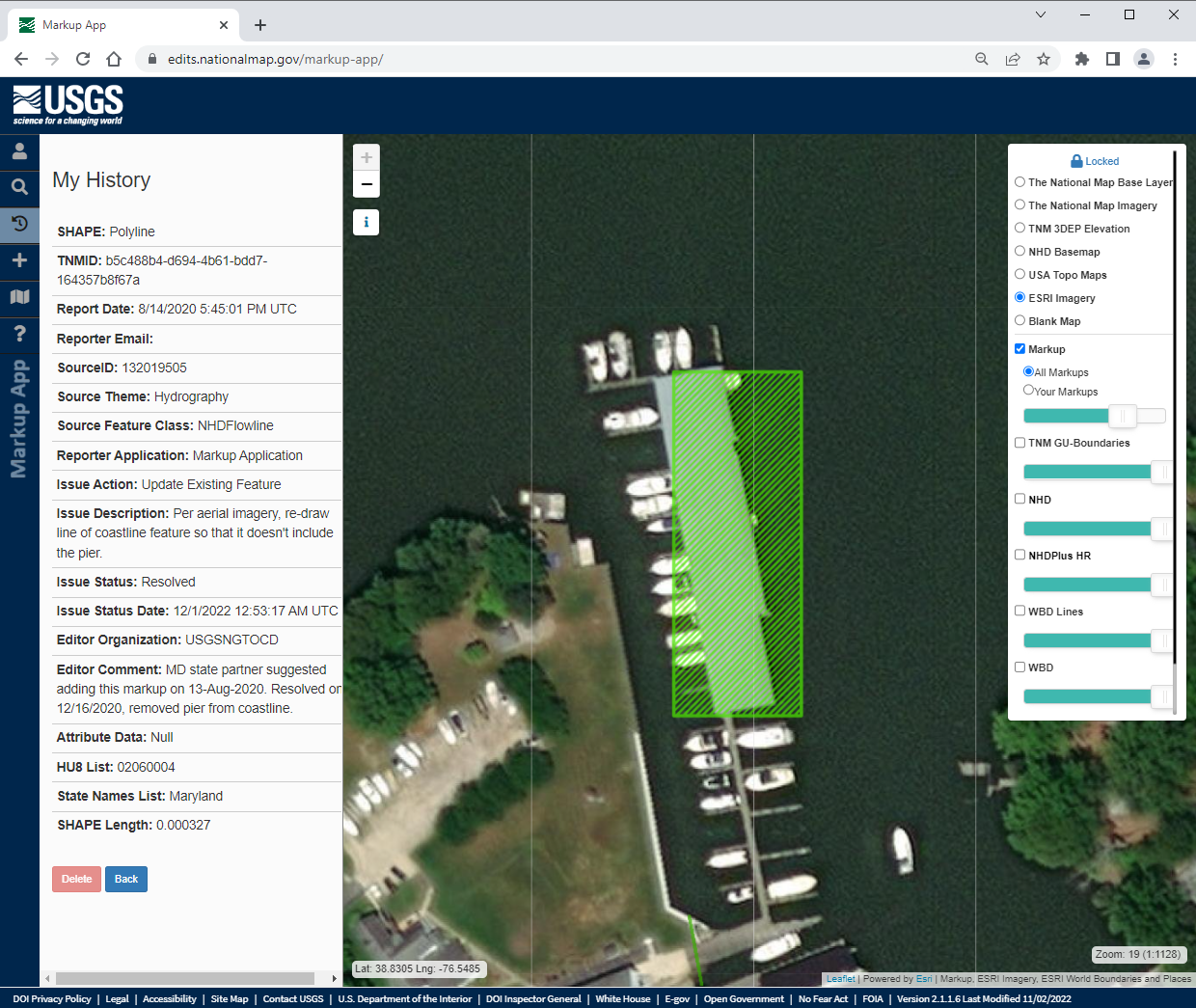
For example, the markup shown below suggests a geometry edit -- redrawing the line geometry for the NHDFlowline coastline feature:

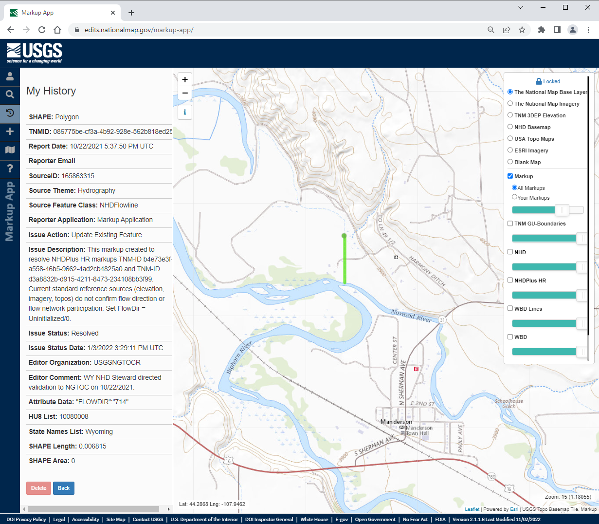
The following markup suggests an attribute edit -- changing the FlowDir attribute to the value of "Uninitialized/0".

When you create a markup, it will contain the following attribute fields:
| Field name (listed in display order) |
Alias Name | Data Type | Allow NULL values | Default Value | Domain/Subtype | Length (Text) | Precision (Numeric) | Scale (Numeric) |
| objectid | OBJECTID | Object ID | n/a | n/a | n/a | n/a | n/a | n/a |
| shape | SHAPE | Geometry | Yes | n/a | n/a | n/a | n/a | n/a |
| LayerID | Shape | Long Integer | No | n/a | Shape Name Domain | n/a | 10 | n/a |
| tnm_id | TNM_ID | Text | No | n/a | n/a | 40 | n/a | n/a |
| report_date | ReportDate | Date | No | n/a | n/a | n/a | n/a | n/a |
| reporter_email | ReporterEmail | Text | No | n/a | n/a | 100 | n/a | n/a |
| source_tnmid | SourceTNMID | Text | Yes | n/a | n/a | 40 | n/a | n/a |
| source_theme | SourceTheme | Long Integer | Yes | 4 | Source_Theme Subtype | n/a | 10 | n/a |
| source_feature_class | SourceFeatClass | Long Integer | Yes | n/a | HydroTheme Domain | n/a | 10 | n/a |
| reporter_application | ReporterApp | Long Integer | No | n/a | SourceApp Domain | n/a | 10 | n/a |
| issue_type_action | IssueAction | Long Integer | No | n/a | ActionType Domain | n/a | 10 | n/a |
| issue_description | IssueDesc | Text | No | n/a | n/a | 400 | n/a | n/a |
| issue_status | IssueStatus | Long Integer | No | 1 | WorkStatus Domain | n/a | 10 | n/a |
| issue_status_date | IssueStatusDate | Date | No | n/a | n/a | n/a | n/a | n/a |
| editor_organization | EditorOrg | Text | Yes | n/a | n/a | 50 | n/a | n/a |
| editor_comment | EditorComment | Text | Yes | n/a | n/a | 400 | n/a | n/a |
| meta_processid | Meta_ProcessID | Text | Yes | n/a | n/a | 40 | n/a | n/a |
| attribute_data | attribute_data | Text | Yes | n/a | n/a | 1073741822 | n/a | n/a |
| state_fips | State_FIPS | Text | Yes | n/a | n/a | 100 | n/a | n/a |
| hu8list | HU8List | Text | Yes | n/a | n/a | 1000 | n/a | n/a |
| statelist | StateList | Text | Yes | n/a | n/a | 200 | n/a | n/a |
| st_length(shape) | st_length(shape) | Double | No | n/a | n/a | n/a | 0 | 0 |
| st_area(shape) | st_area(shape) | Double | No | n/a | n/a | n/a | 0 | 0 |
Please see below for Domain/Subtype definitions:
| Source_Theme Subtype Code | Description | Domain used by Source_Feature_Class field |
| 1 | Cells | CellTheme Domain |
| 2 | Elevation | ElevTheme Domain |
| 3 | Government Units (GU) | GUTheme Domain |
| 4 | Hydrography | HydroTheme Domain |
| 5 | Landcover | LandcoverTheme Domain |
| 6 | Landform | LandformTheme Domain |
| 7 | Structures | StructTheme Domain |
| 8 | Transportation | TransTheme Domain |
| 9 | USTopo | USTopoTheme Domain |
| HydroTheme Domain Code | Domain Type | Value |
| 11 | Coded Values | NHDArea |
| 12 | Coded Values | NHDAreaEventFC |
| 13 | Coded Values | NHDFlowline |
| 14 | Coded Values | NHDLine |
| 15 | Coded Values | NHDLineEventFC |
| 16 | Coded Values | NHDPoint |
| 17 | Coded Values | NHDPointEventFC |
| 18 | Coded Values | NHDWaterbody |
| 21 | Coded Values | WBDHU2 |
| 22 | Coded Values | WBDHU4 |
| 23 | Coded Values | WBDHU6 |
| 24 | Coded Values | WBDHU8 |
| 25 | Coded Values | WBDHU10 |
| 26 | Coded Values | WBDHU12 |
| 27 | Coded Values | WBDHU14 |
| 28 | Coded Values | WBDHU16 |
| 29 | Coded Values | WBDLine |
| 30 | Coded Values | NHDPlusSink |
| 31 | Coded Values | NHDPlusBurntLineEvent |
| 32 | Coded Values | NHDPlusBurnWaterbody |
| 33 | Coded Values | NHDPlusCatchment |
| 34 | Coded Values | NHDPlusWall |
| SourceApp Domain Code | Domain Type | Value |
| 1 | Coded Values | Compare Tool |
| 2 | Coded Values | Manual Edit |
| 3 | Coded Values | Markup Application |
| 4 | Coded Values | Data Management Process |
| 5 | Coded Values | VWE |
| 6 | Coded Values | NHD HEM Sync Process |
| 7 | Coded Values | Batch Load Process |
| ActionType Domain Code | Domain Type | Value |
| 1 | Coded Values | Add New Feature |
| 2 | Coded Values | Update Existing Feature |
| 3 | Coded Values | Delete Feature |
| 4 | Coded Values | Comment Only |
| WorkStatus Domain Code | Domain Type | Description |
| 1 | Coded Values | Submitted |
| 2 | Coded Values | In Progress |
| 3 | Coded Values | Resolved |
| 4 | Coded Values | Wont Fix |
| 5 | Coded Values | In Review |
| Shape Name Domain Code |
Domain Type | Value |
| 0 | Coded Values | esriGeometryPoint |
| 1 | Coded Values | esriGeometryPolyline |
| 2 | Coded Values | esriGeometryPolygon |